Services
|
 |
3-Dimensional Video and Analysis
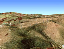 Using
advanced GIS software, we create 3-dimensional video simulations
of potential energy projects. These videos can be used in public
presentations and websites to show a site’s topographical
context and its location in relation to neighboring communities.
We believe that a video simulation can transform a potential project
from words on a page into something people can visualize, understand,
and feel a sense of ownership over. Used alongside our two-dimensional
site maps, our video simulations are valuable tools for site analysis,
giving viewers another way to visualize a project’s relation
to the surrounding environment. Using
advanced GIS software, we create 3-dimensional video simulations
of potential energy projects. These videos can be used in public
presentations and websites to show a site’s topographical
context and its location in relation to neighboring communities.
We believe that a video simulation can transform a potential project
from words on a page into something people can visualize, understand,
and feel a sense of ownership over. Used alongside our two-dimensional
site maps, our video simulations are valuable tools for site analysis,
giving viewers another way to visualize a project’s relation
to the surrounding environment.
Contact us for more information...
|